(WAND WEATHER)- The 60+ degree weather of a little over a week ago seems like a distant memory. In its place: WINTER.
Now, sprinkle in a storm, albeit not as strong as what we had in January, and you have another dose of slippery travel.
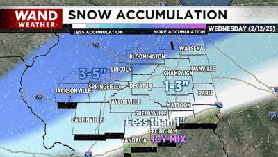
Cue the shoveling and spreading of rock salt. Snow will arrive with said storm Wednesday morning and midday from west to east.
While the overall snow accumulation really won't be all that terrible, sleet and/or freezing rain will mix in for a time across southern locales to create a skating rink on untreated surfaces.
It's actually best to leave the snow on the ground to help "absorb" the freezing rain like a sponge.
Areas to the north and west will likely be primarily all snow, but given a short duration storm, the WAND weather team expects less than a half foot; even in the 3-5" prediction area, the 3" is more likely to occur instead of 5".
Look for snow/ice to wind down later Wednesday afternoon or early evening and stay safe. Temperatures behind this storm will end up in the teens and single digits for a couple of nights.
Copyright 2025. WANDTV. All Rights Reserved.


