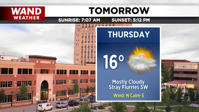

DECATUR, IL. (WAND) - A weak area of low pressure drops to the southwest of us tomorrow. It will bring increased cloud cover from southwest to northeast overnight. Temperatures tomorrow will top off in the mid-teens, and we’ll hang onto the clouds throughout the day.
A strong upper-level low swings through the Great Lakes on Friday, and may allow a few lake-enhanced snow showers to creep into the region. Overall, we’ll be mainly dry as high pressure quickly returns for the start of the weekend.
A weaker shortwave rolls in by the end of the weekend with chances for light snow showers Sunday night. It’s a little early to call snow totals, but this would be a very low-impact event with some areas seeing up to a dusting by Monday morning.
Copyright 2026. WANDTV. All Rights Reserved.


