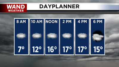

DECATUR, IL. (WAND) - Happy Thursday! It’s another very cold start to the morning with temperatures in the teens and the low single digits. Clouds have taken over across Central Illinois and will hang around for most of the day. Temperatures will only warm up into the teens this afternoon. Most of the area will be dry today, but snow chances will move in for areas south of I-70 this evening. We expect a dusting or less as a low-pressure system moves across the region.
Clouds will clear gradually overnight tonight. This will allow temperatures to drop below 0 for early Friday morning. Friday is looking like the second-coldest day of the week, behind Monday. Wind chills will be in the -5 to -15 degree range. High temperatures will only climb into the low teens for the afternoon with a mix of sun and clouds.
Temperatures for the weekend will remain cold. It will be breezy with gusts around 25 mph. Sunny skies will return for Saturday afternoon. A clipper system will swing by to the north, and we will be right on the edge of seeing some snow chances Sunday night into Monday morning. Snow accumulation looks very low at this point. Warmer temperatures will finally start to move in for next week.
Copyright 2026. WANDTV. All Rights Reserved.


