
DECATUR, Ill. (WAND) - In the wake of a Friday cool front, drier weather sweeps in just in time for this weekend. Not only will the weekend feature lots of sunshine (minus a couple fog patches early Saturday morning), it will remain mild by day and comfortable by night.
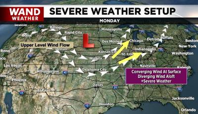
However, a large storm in brewing in the eastern Pacific Ocean. This storm will grow as the pressure lowers in advance of it across the Plains this weekend. Gulf Coast moisture will get involved, along with a wind setup that is just about right for severe storm development, including tornadoes.
Take note of the graphic above. As wind converges at the surface, that air is then forced upward. The wind evenutally diverges tens of thousands of feet about our head. This is a classic setup for rapid supercell development that can spawn a tornado. All modes of severe weather will be possible come Monday afternoon and early night. So, by all means, enjoy this weekend but have a plan in place for when severe weather threatens early next week.
Stay safe, stay sweaty and stay weather-aware.
Copyright 2026. WANDTV. All Rights Reserved.


