
DECATUR, Ill. (WAND) - There are a couple ways for snow to pile up across Illinois during the winter. There are clippers, lake effect, overrunning events and baroclinic zones. Let's discuss the latter.
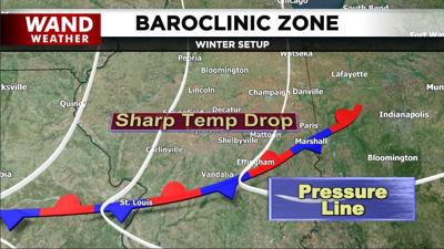
A massive elongated baroclinic zone will establish itself across the Deep South this weekend. That is when the temperature changes drastically along a constant pressure line. This typically happens along and north of a stationary front. We know from history that a baroclinic zone is a dynamic region that often leads to active weather phenomena such as precipitation and storm formation.
Initially, the blossoming precipitation along the baroclinic zone will be too far south of Illinois. However, a large storm off the coast of California will eventually intersect with this baroclinic zone, scooping up plenty of Gulf moisture and tossing it northward into the depths of dangerously cold air over our area. The end result will be accumulating snow this weekend, followed by blowing and drifting.
Stay safe, stay weather-aware and stay warm (feelslike temperatures will bottom out in the minus 15 to minus 25 range Friday morning).
Copyright 2026. WANDTV. All Rights Reserved.


