


DECATUR, IL. (WAND) - Happy Monday! We are starting the week with a fantastic, spring-like forecast! However, with spring temperatures comes spring thunderstorms.
High pressure remains in control today, bringing plenty of sunshine to the region. Temperatures will warm to the low 70s between the sun and strong southwesterly flow. A nearby disturbance will bring clouds later this evening, keeping overnight lows limited to the upper 50s.
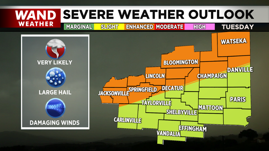
By tomorrow, clouds will continue to build in. We are tracking a cut-off low-pressure system that will lift in tomorrow, bringing warm air, moisture, and lots of thunderstorm fuel ahead of it. As the warm front lifts in on Tuesday evening, strong thunderstorms will likely fire up across central Illinois. What remains uncertain is how many of these storms cross through our viewing area.

The greatest concern for severe weather lies across the Bloomington to Jacksonville line, which is also where the Storm Prediction Center has outlined an enhanced (level 3 out of 5) risk for severe thunderstorms. These storms will be capable of producing strong tornadoes, large hail, and damaging winds. As heavy rainfall continues through Wednesday morning, we’ll also be watching for isolated instances of flash flooding. Stay weather aware as we head into the midweek.
Copyright 2026. WANDTV. All Rights Reserved.


