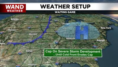

DECATUR, Ill. (WAND) - High heat, high humidity, high available potential energy, yet no severe storms. What gives? The cap. The bane of every meteorologist's forecast.
The cap on the atmosphere will erode, and thunderstorms will return. However, many of us may have to wait until Wednesday. While severe weather is still on the table for Wednesday, it's more of an isolated wind/hail event instead of tornadic.
Another cold front enters the picture Friday night/Saturday morning with yet another round of storms that can turn severe. Cold weather will return for a cameo in its wake. It'll be best to stay ahead of these storms with the WAND weather app. It's a free download from your smartphone's app store.
As always, stay safe, stay sweaty and stay weather-aware.
Copyright 2026. WANDTV. All Rights Reserved.


