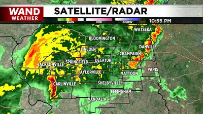

ILLINOIS, (WAND) - The National Weather Service has canceled several tornado warnings across central Illinois following severe weather that swept the area Friday evening.
The National Weather Service issued several Tornado Warnings to much of the area, with the most recent for Champaign and Piatt Counties ending at 10:30 p.m.
Those in the warned areas were urged to seek shelter immediately.
TRACK THE STORMS | Click here for a weather radar to keep an eye on the storms
Be sure to stay ahead of the weather and possible severe storms in the future by downloading the WAND Weather App.
Copyright 2026. WAND TV. All rights reserved.


