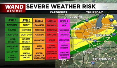

DECATUR, Ill. (WAND) - Parts of the area were able to pick up rain and a heavy thunderstorm earlier. The unfortunate part was the few pockets of damage associated with said storms. If there is a silver lining from the earlier storms, it's that a more stable layer of air has developed at ground level in their wake. While that doesn't mean severe storms can't return later tonight, it does make it more difficult for a funnel cloud to penetrate that stable layer.
Thunderstorms that return tonight will linger into the wee hours of Thursday morning before diminishing. Additional pockets of wind damage are possible along with flooding, so caution is advised when venturing outdoors. Make sure you have a way to receive critical warnings, especially during the middle of the night.
The final push of our latest cold front will arrive Thursday evening. A developing squall line of thunderstorms can spawn tornadic activity from northwest to southeast throughout the first part of the night. More refreshing weather will be the ultimate prize behind all of this for Friday.
Stay safe and stay weather-aware.
Copyright 2026. WANDTV. All Rights Reserved.


