
DECATUR, Ill. (WAND) - The National Weather Service is continuing efforts to survey recent storm reports from Monday. The survey crew was concentrating on the area from southeast Logan County, DeWitt, northern Piatt, to northern Champaign County. At the time of writing, there is one confirmed tornado in this area, but no specific details on time and intensity. WAND weather will pass along more information when it is available.
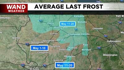
Now, the weather shifts away from a severe threat to more of a mundane hit/miss shower and thunderstorm pattern tonight. An additional cold front will arrive late week with the threat of light showers or virga. However, it's the air mass in the wake of said front that is more important. Planting season has already been hampered by recent storms. The weather concern shifts to cold. As wind diminishes Friday night into Saturday morning and cloud cover dissipates, the stage is set for possible patchy frost. This would be slightly ahead of the average last frost date, a few days later in May.
Take care of that tender vegetation, stay warm and stay weather-aware.
Copyright 2026. WANDTV. All Rights Reserved.


