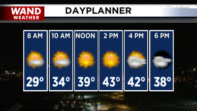

DECATUR, IL. (WAND) - Happy Monday! It’s a chilly start to our morning with feels-like temperatures down in the teens across Central Illinois. Temperatures will slowly rise out of the basement throughout the day, and our high temperatures are expected to be about 10 degrees above average, reaching the mid-40s, with mostly sunny skies.
Winds will gust around 20 mph through the night, and temperatures will drop back close to freezing in the low 30s. Tuesday is the warmest day of the week, with southerly winds bringing in much warmer temperatures in the mid-50s, accompanied by mostly cloudy skies.
A cold front will move in overnight from Tuesday into Wednesday morning, bringing chances of showers and a very light wintry mix. No accumulation is expected at this time. Temperatures will be falling throughout the day on Wednesday and will plummet through the overnight hours.
You can expect cold temperatures through the rest of the week, with highs staying below average on Thursday. Another cold front on Friday night will bring in a few flurries, and this will bring in even colder temperatures for the weekend.
Copyright 2026. WANDTV. All Rights Reserved.


