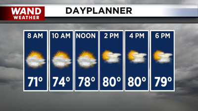

DECATUR, IL. (WAND) - Happy Monday! Temperatures will be much cooler this week after the brutal heat and humidity from the weekend. We will see temperatures in the mid to upper 60s this morning with a mix of clouds and sun throughout the day. Temperatures will warm up much more slowly, with afternoon highs in the low 80s. An isolated pop-up storm can’t be ruled out, but most of the area will be dry.
Tomorrow morning will be mild in the low 60s. The sunshine will return for Tuesday and Wednesday with temperatures starting to creep back into the upper 80s. Humidity will slowly build back into the area throughout the week, with the heat index back in the 90s by Wednesday afternoon.
Hot and humid conditions will take over by Thursday afternoon. Temperatures will be warm in the upper 80s. Rain chances will also increase throughout the day, with scattered storms expected by Thursday afternoon. The heat index on Thursday will be close to triple digits.
Looking ahead
The weekend is looking hot and humid with temperatures warming into the mid-80s on Saturday and Sunday afternoon. The heat index will be in the 90s through the weekend, and overall, this is right where we should be for this time of year.
Copyright 2026. WANDTV. All Rights Reserved.