
DECATUR, Ill. (WAND) - Severe storms developed earlier today along a cold front over the Ozarks. These storms continued northeastward into Wisconsin and will be knocking on our door tonight.
There are a few things to take away from these thunderstorms. Yes, there is the risk of severe weather. While the prospect of a lone tornado isn't zero, there are more parameters against a tornado forming this far east as opposed to one forming. The cover of darkness will also impact the intensity of the storms, and the coverage area to severe weather (hail/wind) will likely be diminishing from west to east across the state tonight. There certainly can be pockets of damaging wind; it's just not an all-nighter. Rain and thunder can linger until near daybreak, the farther east you are located. However, the risk of severe weather will dissipate hours before then.
Gusty winds and high humidity will linger throughout the night before a more refreshing air mass returns Thursday.
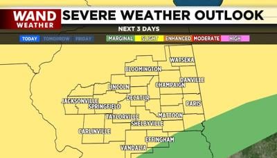
The next prospect for severe weather arrives Friday night, after dark. For now, all modes of severe weather are possible with this feature.
Stay safe and stay weather-aware.
Copyright 2026. WANDTV. All Rights Reserved.


