
DECATUR, Ill. (WAND) - Ever hear of the old proverb that is the title of this blog? It stems from the transition from Winter To Spring being fickle and changing rapidly at times.
Sure, WAND Weather is expecting a mild April. That's not to say it can't get cold at times. One of those times just so happens to arrive tonight and tomorrow. The past couple of nights have been chilly, but this will actually be the coldest part of our most recent air mass.
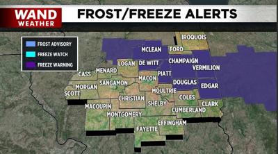
Despite a freeze warning being in place for parts of the region overnight, not everyone will have a freeze. The reason? A light breeze lingering into the night and an increase in cloud cover. A weak storm will slide northwest to southeast across the state, producing a band of light rain and snow showers. Yep, snow. No need to panic. Road surface temperatures will remain above freezing, along with some air temperatures tonight. The result will be no road accumulation. The southern and western tier counties that do pick up some rain and snow may end up with a bit of slush on the lawn for a few hours, but that's about it. The record for the latest 0.1" of snow is May 2, 1929. We're nowhere close to that.
Stay warm, and stay weather-aware.
Copyright 2026. WANDTV. All Rights Reserved.


