
DECATUR, Ill. (WAND) - First things first, the weather to start this weekend will be fabulous. It won't be as warm as Friday due to a cold front arriving from the north, but still fabulous.
Now, about that cold front. It's a dry passage, only sparking some clouds under the cover of darkness later on. The second cold front that is hot on its heels is the first of three key ingredients for snow!
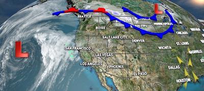
The second cold front stalls near I-70 later this weekend. It allows the depth of cold air to increase. Meanwhile, the next key ingredient is Gulf moisture building up from the South. That moisture will run over the top of that stalled front and into the depths of colder air. The other ingredient is the massive storm over the Pacific Ocean. A piece of that will break off and travel into the state Sunday night and Monday morning. This will provide extra lift to the moist air from the Gulf. The end result will be a blossoming area of mixed precipitation that will transition to snow when it is heaviest. Slippery travel ensues through Monday morning before precipitation tapers off and everything melts.
Always remember: stay safe and stay weather-aware.
Copyright 2026. WANDTV. All Rights Reserved.


