

(WAND) - Skies will remain sunny across central Illinois for the end of the workweek.
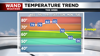
Temperatures will continue to climb with highs near 80° for today & Thursday; while Friday soars into the low 80s. The warmest day will be Saturday with highs in the low to mid 80s; with extra clouds rolling into the area ahead of a cold front.
The cold front is forecasted to pass through Central Illinois throughout Saturday night; which could include a brief shower. Sunday will be cooler behind the front around 70°, while being breezy. Temperatures will continue to fall into the start of next week; with highs around 60° on Monday & mid to upper 50s by Tuesday. Skies on Sunday through Tuesday will be a mix of sun & clouds; with a stray shower or sprinkle possible for Monday & Tuesday. Frost will be possible for Monday & Tuesday nights, with lows into the mid 30s.

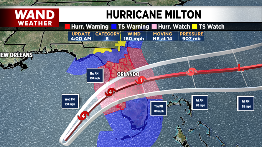
Hurricane Milton regained Category 5 status on Tuesday afternoon & it has begun its northeast trajectory towards Florida. Milton continues currently as a Category 5 & forecasted to make landfall over the west coast of Florida, specifically closer to Sarasota late tonight, while weakening to a Category 4. It will maintain hurricane status as it exits Florida on Thursday. Storm surge near the center & just south could be as high as 15 feet, while the wind field expands before & after landfall. The heaviest rainfall is projected to occur on the northern side of the storm from Orlando to Tampa, while areas around the center & south deal with the chance of isolated tornadoes.
Meteorologist Ulises Garcia
Copyright 2024 WAND TV. All rights reserved.


