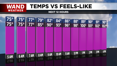

DECATUR, IL. (WAND) - Happy Monday! We have the hottest weather of the season so far on tap for the next few days. Sunday was the first time in two weeks that we hit the upper 80s, so it has been a mild June as far as temperatures go. Temperatures will hit the low 90s today with mostly cloudy skies, so expect it to feel very much like it did on Sunday.
The two hottest days of the week will arrive on Tuesday and Wednesday. Expect nothing but sunshine both days as temperatures soar into the mid-90s by the afternoon. The heat index will make it feel closer to 105 to 110, so make sure to take precautions if you are outside for an extended period of time. Overnight lows will be very warm in the 70s, so don’t expect much relief from the heat.
Scattered storm chances will arrive on Thursday. While temperatures will stay very hot in the 90s, it will be a degree or two cooler on Thursday and Friday afternoons. Scattered showers will persist through the weekend, but we shouldn’t see much rain on the 4th of July. Temperatures will cool down into the 80s by Sunday.
Copyright 2026. WANDTV. All Rights Reserved.


