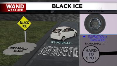

DECATUR, Ill. (WAND) - The thermometer read 50 degrees in some areas today. It'll do so again Thursday. While that matters in terms of how road surface temperatures behave, there is still the large concern of black ice overnight/early Thursday morning.
The latest storm to pass through will bring a combination of rain, sleet and snow that will end as a touch of drizzle or freezing drizzle early Thursday morning.
Doppler radar has been lit up most of Wednesday, but precipitation hasn't reached the ground. As the column of air above our heads is saturated (humidity up to 100%) from top to bottom, precipitation will begin to hit the ground. Initially, a lot of melting will take place. However, as the air temperature dips to the freezing mark and just beyond, anything that is wet and/or slushy will begin to freeze. Initially, it will be bridges and overpasses that typically mimic the air temperature. Additional roads that will run a degree or two higher than the air temperature can follow closer to daybreak.
To be on the safe side, give yourself plenty of time to reach your destination if it is before 8 or 9 a.m. Thursday. Treated surfaces likely won't have any problems at all. Quite the opposite can be said about untreated surfaces.
Stay safe and stay weather-aware.
Copyright 2026. WANDTV. All Rights Reserved.


