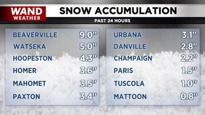

DECATUR, Ill. (WAND) - Cold goes to warm this week in another chapter of this crazy fall weather. However, some areas got a decent dose of lake effect snow to kickstart the work week. The heaviest amounts, as suspected, were near or east of I-57 in Iroquois county. Accumulation tapered rapidly farther south, although an inch of snow was reported along I-70 near IL-1. Farther west, only flurries dotted the horizon from time to time Sunday and Sunday night.
While we are no strangers to lake effect snow, it is not the most common way to receive snow in the cold months. The average wind direction is from the northwest, which takes the plume of accumulating snow in Indiana and Michigan. So, the correct wind trajectory has to be met to get snow this far south in Illinois.
Speaking of wind trajectory; a shift will take place under the cover of darkness tonight. That won't alleviate the chill in the air in the short term. However, warmer weather is not too far away.
Stay tuned, stay safe, and stay warm out there.
Copyright 2025. WANDTV. All Rights Reserved.


