
(WAND) - Although April has seen the highest number of tornadoes in central Illinois this year, May is typically the month known for the most severe weather. After a quieter weekend spent cleaning up from recent storms, severe weather is expected to return over the next 24 hours.
The first wave of heavy to severe storms will bring strong winds and heavy rainfall, which could lead to localized flooding later tonight. There's a possibility of hail, potentially the size of a quarter, and an isolated tornado cannot be ruled out. It's important to ensure you have a way to receive any severe weather warnings overnight.
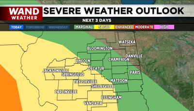
A second round of severe storms is expected Tuesday afternoon. This wave will also feature strong winds and hail, with the risk of an isolated tornado still present. Always know where to go during a severe storm and prioritize your safety.
Stay weather aware with the WAND Weather App. Click here for a link to download the app on your phone.
Copyright 2025. WANDTV. All Rights Reserved.


