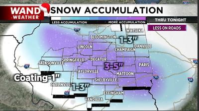

DECATUR, Ill. (WAND) - The first of two separate accumulating snow events is underway. While the duration of snow will be relatively short-lived, the heavier bursts of snow will tally up at a half inch to an inch per hour!
Snow is expected to taper off to flurries before midnight for western locales, to a couple hours after midnight near the Illinois/Indiana border. So, you shall wake up tomorrow morning to a fresh batch of snow.
Clouds will likely linger tomorrow underneath an inversion (warm air aloft/colder at the ground). There may even be a couple tiny flurries. However, the next accumulating band of snow will arrive Saturday. This one will likely arrive as flurries in the morning and quickly pick up in intensity before exiting later Saturday evening.
In general, another 3-6" is expected north of IL-16 and 1-3" south. It will definitely make for difficult travel, especially given the powdery nature with a bit of blowing and drifting. Temperatures in the wake of these storms will bottom out below zero this weekend with dangerous feelslikes temperatures approaching minus 20 or minus 25.
Stay safe out there, stay warm and stay weather-aware.
Copyright 2025. WANDTV. All Rights Reserved.


