
DECATUR, Ill. (WAND) - Severe weather that moved through central Illinois on Monday has finally let up, as tornado watches have expired throughout the region.
The National Weather Service in Lincoln had issued a Tornado Watch covering Clark, Coles, Cumberland, Douglas, Edgar, Vermilion, Clay, Crawford, Effingham, Jasper, Lawrence and Richland counties, which includes cities like Charleston, Danville, Effingham, Mattoon and Tuscola.
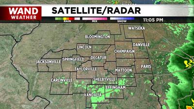
The watch had expired at 11 p.m.
LIVE RADAR | WEATHER CAMERAS | WEATHER BLOG
Earlier Monday, several warnings for both tornadoes and thunderstorms were issued across Central Illinois as strong storms raced east out of Missouri.
PHOTOS: Severe weather leaves behind damage, rainbows in its wake across central Illinois
Areas that saw heavy rain and storms on Monday have seen the severe risk reduce, but it is not entirely gone, according to the WAND Weather team.
There have been no reports of significant damage from Monday morning's storms. Widespread power outages across several counties knocked out electricity to thousands.
A grain truck was blown over in Christian County, according to the Christian County EMA Director. Nobody was hurt. Several trees were also knocked down.
The Effingham County EMA Director reported a tree into a mobile home. No injuries were reported.
Other areas saw heavy rain and strong winds.
Tuscola CUSD 301 announced on Facebook that the district had put shelter-in-place procedures in place after a tornado warning was issued for the area. Superintendent Gary Alexander said that all after-school activities would be canceled on Monday due to the weather.
DeLand-Weldon CUSD #57, based in Piatt County, said on Facebook that the school took damage during the storm and will be closed on Tuesday. The district added that it will not be an e-learning day for students.
Copyright 2026. WAND TV. All rights reserved.


