• CLICK HERE FOR THE MOST UP-TO-DATE FORECAST INFORMATION.
The following story is from Thursday's forecast. Click above for the most recent forecast information from the WAND Weather Team.
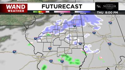
DECATUR Ill. (WAND) — A disturbance will drop through the area Thursday and bring a light wintry mix. Across the northeastern half of central Illinois, a dusting to an inch of snow is possible.
This clipper system will usher in much colder air with highs in the 20s through Monday. Overnight lows will be in the teens.

While Friday and Saturday look to remain calm with sunshine, Sunday looks to be the day of interest in this forecast.
The National Weather Service has issued a Winter Storm Watch for several central Illinois counties. The watch was issued due to the potential for heavy snow and ice. Gusty winds could also create blowing and drifting snow.
The Watch is in effect from late Saturday through Monday morning.
It's looking more and more likely that moderate to heavy snow will blanket central Illinois late this weekend into Monday.
While timing remains steadfast, accumulation remains unknown and varies across various models.
It's too early to decide on how much snow will fall and where.
Make sure to download the WAND Weather App for the most up-to-date information.
Copyright 2025. WAND TV. All rights reserved.


