
DECATUR, IL. (WAND) - Strong southwesterly flow today brings not only warm air, but lots of moisture. The big question is, can we saturate the air at the surface enough to support rain tonight? Details below:
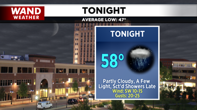
A warm front rolled through earlier this morning, bringing warm air to central Illinois. Tonight, temperatures remain mild under a few clouds as a cold front rolls in. A lot of dry air remains in place near the surface this evening, although some moisture may permeate later overnight. This may allow for some light, scattered showers this evening, but the highest chances will remain farther east. We can’t rule out a rumble of thunder or two farther east as well, but the severe weather chance is more or less zero.
A spotty, isolated shower may linger for those east of I-57 early Wednesday morning, but most will quickly return to sunny skies by midday as dry air returns behind the front. Better chances for widespread heavy rainfall will return on Thursday night and Friday. Although severe potential is high across the plains states, the early/midday arrival time of the storms may limit that potential here at home.
Have a great night!
Copyright 2026. WANDTV. All Rights Reserved.


