
DECATUR, Ill. (WAND) - Several bouts of wet weather will strike the state over the remainder of this week and into the start of Easter weekend. Tonight's cold front is the first wave.
As the cold front settles southward, an increase in coverage to thunderstorms is expected. Hail will be the biggest concern with this feature as it progresses through our state. If you are a light sleeper, this one could keep you up at times later tonight.
Colder, wet weather will take over Wednesday, although the coverage area of rain will diminish with time.
The next threat of thunderstorms arrives Thursday afternoon and night. Yes, there is the risk of severe weather. This could be the biggest threat for severe weather this week, so stay tuned for updates.
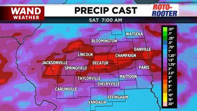
If this weren't enough, another cold front arrives Saturday. In advance of it, rain and heavy thunderstorms will break out as early as Friday night. Rain will linger for a good part of Saturday before the chill of early spring takes hold for Easter Sunday. If you are planning on attending morning mass, it'll be best to have a winter coat. Feelslike temperatures are expected to be in the 20s, waking up on Easter Sunday.
Stay safe and stay weather-aware.
Copyright 2026. WANDTV. All Rights Reserved.


