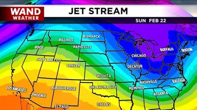

DECATUR, Ill. (WAND) - The giant sliding board of cold is back! Air that originates over Canada will continue to slide into the state over the course of this weekend and early next week. The coldest time frame will likely be Sunday and Sunday night. This is when the thermometer will not be able to crack the freezing mark for most locales.
Given the depth of cold air, any precipitation that falls will be in the form of snow. The depth of dry air will also play a factor to limit the amount of snow flurry activity, so WAND weather is only expecting virga (precipitation that evaporates after falling from the cloud) or harmless flurries Saturday morning. A little more robust feature will pass through Sunday morning with the chance of light snow or flurries. Either way, the terrible drought lingers.
Stay safe, stay warm and stay weather-aware.
Copyright 2025. WANDTV. All Rights Reserved.


