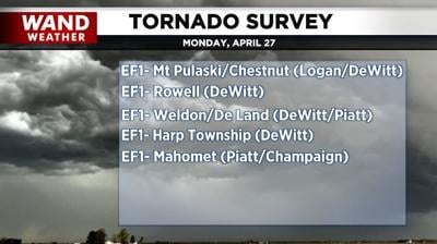

DECATUR, Ill. (WAND) - Five EF1 tornadoes ripped through parts of central Illinois on Monday, all of which took place during the second event during the evening hours. A 58-mile stretch of near continuous damage occurred from southern Logan County to northern Champaign.
Since EF1 tornadoes rarely behave in such a manner, the National Weather Service dug deeper into where the tornadoes lifted and touched back down, narrowing the number to four separate entities. The other tornado was a brief touchdown four miles east-southeast of Wapella, in DeWitt County.
It all started at 6:14 p.m. when an EF1-rated tornado touched down near the intersection of 1250th Ave and 600th Street in south-central Logan County. The tornado reached peak intensity of 90 mph with a 400-yard maximum width as it crossed the northwest side of Mount Pulaski, then south of Chestnut, before moving into DeWitt County.
The second piece of this debris corridor was also an EF1 tornado. The peak wind of 88 mph is estimated by damage from near Rowell, across US51, to near Ospur in DeWitt County.
The third EF1 tornado packed 100 mph winds. This feature started eight miles west of Weldon in DeWitt County and traveled to just one mile north of DeLand in Piatt County. The DeLand/Weldon High School sustained damage.
The last piece of this 58-mile terror was an EF1 with 93 mph winds. This tornado spun up west of Galesville in Piatt County at 6:55 p.m. and traveled through the north side of Mahomet in Champaign County before dissipating at 7:09 p.m. just northeast of Lake of the Woods.
The silver lining out of this is that no fatalities or injuries were reported.
As always, thank you for staying safe with WAND weather. No tornadic activity is expected for several more days. Take time to help your neighbors and yourself.
Copyright 2026. WANDTV. All Rights Reserved.


