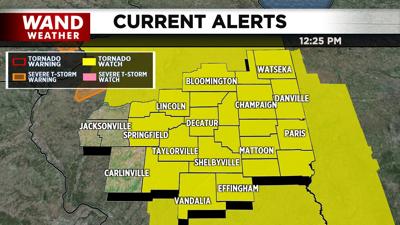

DECATUR, Ill. (WAND) - The National Weather Service issued a Tornado Watch for dozens of Illinois counties Wednesday afternoon.
The watch is in effect until 9 p.m. Wednesday.
The WAND Weather Team is monitoring a storm system approaching Illinois that is expected to have strong winds, hail, and has the potential for tornadoes. Winds could exceed 60 miles per hour.
A Wind Advisory issued earlier is in effect until 7 a.m. Thursday because of wind gusts approaching 50+ miles per hour. That's in addition to a Red Flag Warning across parts of Illinois due to drought conditions leading to elevated fire risks.
Wednesday's storms are expected along the I-74 corridor and could get stronger as they move east.
Stay informed with the WAND Weather App by clicking here to download it on your phone. You can also get regular weather updates on the WAND Now app that's available on your phone, tablet, and smart TV.
Copyright 2025 WAND TV. All rights reserved.


