
• CLICK HERE FOR THE MOST UP-TO-DATE FORECAST INFORMATION.
The following story is from Saturday morning's forecast. Click above for the most recent forecast information from the WAND Weather Team.
(WAND)- The first winter storm of 2025 is closing in on central Illinois this weekend. Since the center of the storm resides along the West Coast, snow is not expected to arrive until almost midnight Saturday night or shortly after near the Illinois River.Snow will expand across the remainder of the area overnight and Sunday morning. This will allow plenty of opportunity during Saturday to prepare for the storm.
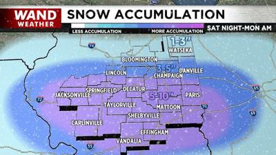
There are a few things to keep in mind as you glance at the accumulation map.
First, the storm track will be south of Illinois. This will ensure that all precipitation will be frozen, but not necessarily all snow.
Sleet and freezing rain can mix in at times, especially across southern counties.
However, a storm track too far south will also limit accumulation the farther north you reside. Second, the column of air above our heads needs to be saturated to provide good snowflake growth and rapid accumulation.
This many only happen for a few hours during Sunday afternoon and early evening during the height of the storm. Third, severe thunderstorms will form to our south, helping to disrupt the energy and moisture transport from the Gulf of Mexico.
The timing and duration of these severe storms will greatly impact the intensity of the frozen precipitation. It is because of these factors that the WAND Weather Team leans heavily toward the lower end of the accumulation range you see on the accompanying map.
There is still concern that thunderstorms can form as close as southern Illinois early Sunday afternoon, aiding in precipitation rates, but there is no slam dunk.
Plan for slippery, slow travel with the worst conditions during the storm being the second half of Sunday. This excludes northern locales that may have little accumulation.
Behind this storm, wind gusts of over 35 mph are likely to continue Monday.
Additional morning flurries that day will lead to no consequences, but blowing and drifting snow will continue to hamper clean up operations in open areas.
WAND will have coverage of this storm throughout the weekend as well as Monday, on air, online and on the WAND family of free apps.
Copyright 2025 WAND TV. All rights reserved.


