
DECATUR, IL. (WAND) - Happy Wednesday! Most of Central Illinois saw very significant rainfall yesterday. Springfield set a new March 3rd record with 2.43 inches of rain recorded. Storms yesterday reached severe limits in several areas, and we have much more rain on the way today.
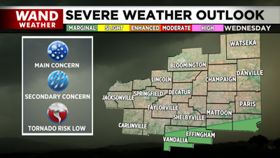
Scattered showers will taper off through the morning, giving us mostly dry conditions through the early afternoon. Rain chances will increase through the afternoon, and another round of showers and some strong storms will be possible through the evening. The best chances of storms becoming severe will be along and south of I-70. The severe weather threat will exit overnight, but another round of storms and steady rain is expected through early Thursday morning.
Most of the day on Thursday looks warm and quiet with temperatures warming up into the 60s. Temperatures will soar on Friday as a warm front moves through the region. This could trigger another round of strong to severe storms for late Friday evening. Rain will linger overnight into early Saturday morning, but most of the weekend is looking dry and warm.
Copyright 2026. WANDTV. All Rights Reserved.


