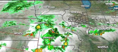

DECATUR, Ill. (WAND) - Rain and severe weather are about the last thing we need right now. Unfortunately, Mother Nature has a different idea.
Despite a weak cool front running north to south, past I-70 tonight with a dip in humidity, more rain will return. You may think a dip in humidity is a good thing, but the front that moves past us stalls nearby and reloads with Gulf Coast moisture. The end result will be blossoming areas of rain with embedded thunderstorms overnight through the first half of Friday. We won't be completely done Friday afternoon/evening, but at least the coverage area of thunderstorms will begin to diminish. Many areas will pick up at least three-quarters of an inch of rain over the next 24 hours. Those that receive more than one thunderstorm can have a quick 1-3". A flood watch is in effect for this area and south of I-72.
Give yourself extra time to reach your destination Friday. Oh, by the way, the respite in humidity will only be a cameo. FeelsLike temperatures will approach 100 as early as Sunday afternoon, and likely linger through America 250.
Stay safe, stay sweaty and stay weather-aware.
Copyright 2026. WANDTV. All Rights Reserved.


