
DECATUR, Ill. (WAND) - It's a warm front/cold front scenario shaping up. Tonight's passage of a warm front will lead to hit/miss showers and a thunderstorm (non-severe).
Behind tonight's warm front, Thursday turns out even warmer! Record high temperatures will be set for the date across most, if not all, of central Illinois. There may even be a couple spots where the all-time March record high temperature will be set. Champaign has the highest March record at 85 degrees.
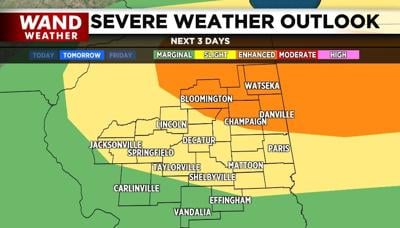
Unfortunately, this warmth comes with plenty of humidity and a cold front. As the cold front approaches and lowers the pressure field, the strong cap on the atmosphere will begin to erode. Initially, there will be a stable pocket of air at ground level, but it is unclear as to whether or not this will be overcome by the strong nature of the storms. That said, a strong tornado cannot be ruled out. Damaging hail will be the biggest concern at the onset of the storms Thursday evening, followed by damaging wind and heavy rain. It's best to know where your safest location is before Thursday evening.
WAND weather will continue to monitor the progression and strength of these storms. Stay tuned, stay safe and stay weather-aware.
Copyright 2026. WANDTV. All Rights Reserved.


