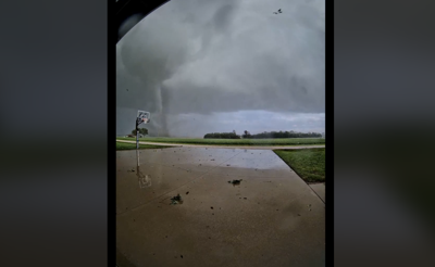

(WAND) - The National Weather Service has now confirmed that at least seven tornadoes touched down in central Illinois Wednesday, including an EF-3 in Effingham.
>>PHOTOS: From dark skies to debris - Storm aftermath across central Illinois
According to the Effingham County Emergency Management Agency, the National Weather Service in Lincoln confirmed an EF-3 tornado touched down in the county.
The tornado traveled over 26 miles, had an estimated peak wind speed of 150 mph and had a max width of 500 yards.
It first touched down in Beecher City along E State Highway 33, eventually moving east through Shumway. The tornado intensified to EF-3 status as it reached the northern outskirts of rural Effingham.
Effingham County EMA said that after the storm left Effingham, it was tracked crossing Interstate 70 and maintained its EF-3 status as it moved east into rural Teutopolis.
The tornado eventually weakened to EF-2 intensity as it moved across the Effingham-Jasper county line, with its path ending as it lifted along N 200th St., slightly north of Island Grove.
Effingham County EMA shared that multiple non-life-threatening injuries had occurred in the path of the storm, but no deaths were reported.
The Coles County tornado hit Charleston and part of Mattoon. NWS said it was an EF-2 with peak winds of 116 mph.
The tornado traveled for just under 14 miles and had a max width of 800 yards.
It developed four miles north of Mattoon and tracked southeast, damaging homes, trees, and power lines as it crossed US-45. The tornado intensified as it crossed County Road 700E, lifting the roof off a family home and uprooting large trees.
The tornado flipped a semi truck as it crossed Interstate 57, resulting in one injury.
The tornado tracked eastward, impacting the north side of Charleston. It heavily damaged buildings on the western outskirts of town, damaged the fairgrounds, and multiple buildings and trees in town before lifting two miles east of Charleston near Highway 16.
The Pawnee tornado was rated an EF-0 by the NWS. It had peak winds of 85 mph and traveled for 5.72 miles. The max width was 200 yards. No injuries have been reported in connection with that tornado.
The tornado touched down about 1.5 miles west of Pawnee Junction near the Interstate 55 exit before traveling east across I-55, affecting Commanche Village and Pawnee, before dissipating 0.75 miles southeast of Pawnee. It produced mainly tree damage along with minor damage to home soffits and roofs.
According to the NWS, there were EF-1 tornadoes in Springfield, Blue Mound, Bethany and the Grove Township.
The Springfield tornado had peak winds of 100 mph and traveled just over 24 miles.
NWS said the tornado in Blue Mound had a maximum wind intensity of 110 mph and traveled around 10 miles.
Copyright 2026. WAND TV. All rights reserved.


