
DECATUR, Ill. (WAND) - Ever get caught daydreaming in school when you were a kid? I used to get that a lot, followed by "get your head out of the clouds." I'd love to run into my high school biology teacher now and tell her, good luck getting your head out of these clouds.
A saturated column of air and limited mixing of air at the ground have allowed dense fog to form in many locales. About the only thing that will get your head out of the clouds will be a flight to a different destination. Low-level moisture will continue to flow freely in from the Gulf. The combination of this and our latest wave of low pressure will lead to another round of rain with embedded thunderstorms into Thursday morning. This is all that the weather doctor prescribed, but for some, it will be too much too fast with isolated flooding.
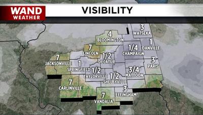
Soooo, it's either fog or rain and thunderstorms to reduce visibility for us. That will scream extra time to arrive at your destination safely. A light westerly breeze returning behind this next batch of rain has the potential to break some of the clouds apart later Thursday. Fingers crossed!
Stay safe and stay weather-aware.
Copyright 2026. WANDTV. All Rights Reserved.


