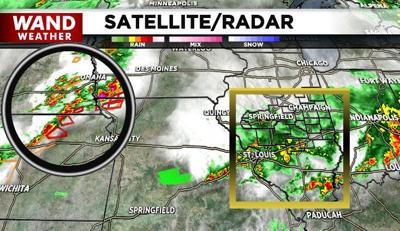

DECATUR, Ill. (WAND) - Rain with an embedded thunderstorm (boxed area) will wind down in coverage and intensity early tonight. That will be a welcome break to areas that picked up over three inches of rain earlier, primarily across southern Fayette and southern Effingham counties.
Unfortunately, Mother Nature isn't done with us yet. Severe storms (circle area) off to our west will arrive during the wee hours of Tuesday morning. As of now, these storms are forecast to weaken as the parent storm bypasses us well to the north. That's not to say there can't be an isolated severe thunderstorm, but it wouldn't be tornadic.
Thunderstorms throughout Tuesday should be far more misses than hits; nothing that compares to Monday's rain coverage area. That piece of info, along with a little sun, will make for a warmer, humid day. If humidity isn't your thing, fear not: Wednesday and Thursday will cool down again ahead of Friday storms.
Stay sweaty and stay weather-aware.
Copyright 2026. WANDTV. All Rights Reserved.


