(WAND) — It's been a windy Tuesday, and unfortunately that is only the beginning of our weather woes.
The combination of dry topsoil, recently plowed fields and gusty winds are creating blowing dust over parts of central Illinois this afternoon; the result being occasional road closures.
The National Weather Service has issued a dust storm warning for the following areas until 8 p.m. this evening: Peoria, Champaign, Bloomington, Decatur, Normal, Urbana, Pekin, Danville, East Peoria, Morton, Lincoln, Rantoul, Clinton, Monticello, Hoopeston, Eureka, Washington, Savoy, Mahomet, and Mt. Zion.
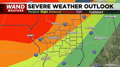
Meanwhile, heavy to severe thunderstorms crossing Iowa and Missouri are intensifying, leading to supercells that will be associated with tornadic activity. The parent storm responsible for these storms will run well to the northwest of central Illinois, but close enough to bring the threat of a tornado, especially to areas near and west and I-55 late this evening.

Additional storms will form along a dryline (the zone where southerly, humid air runs into drier west winds) farther south through Missouri. These storms will target areas farther south and east across central Illinois with damaging wind gusts and hail being the biggest concern closer to and just after midnight tonight.
Since these storms will have their greatest impact under the cover of darkness, make sure to have a way to keep up with weather watches and warnings when they are issued. The free WAND weather app and/or NOAA weather radio, along with WAND-TV are great ways to stay informed. Stay safe and be weather aware.
Copyright 2024. WAND TV. All rights reserved.


