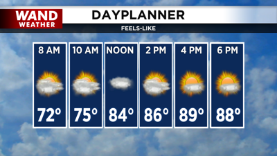

DECATUR, IL. (WAND) - Central Illinois will see a calmer day overall Friday, though dense fog will be the main concern for early morning commuters.
A few showers and stray storms will move through early this morning, but most of the area will remain dry. The bigger impact for your commute will be dense fog — a Dense Fog Advisory is in place for the eastern half of Central Illinois until 8 a.m.
Once that fog clears, we'll see a nice mix of sun and clouds for the afternoon, with high temperatures reaching the mid-80s — right where they should be for early August.
Heat and humidity take over the weekend
Don't get too comfortable with those mild temperatures. Hot and humid conditions will really take over this weekend.
Overnight Friday, temperatures will stay mild, with lows in the upper 60s and low 70s. But Saturday and Sunday will feel much different. High humidity will build into the region, and feels-like temperatures will climb to the mid-90s both days.
Isolated storm chances will develop Saturday and Sunday, but they will be very hit-or-miss. Most of the area will stay dry.
Monday brings the hottest day of the week
Monday is shaping up to be the hottest day of the next seven days, with high temperatures close to the low 90s. When you factor in the humidity, feels-like temperatures will approach 100.
Active pattern arrives midweek
An active weather pattern will arrive by the middle of next week. Chances for organized storms will increase, but it's too early to pinpoint exactly when those storms will arrive or how strong they could be. Stay with us for updates as we get closer.
Copyright 2026. WANDTV. All Rights Reserved.


