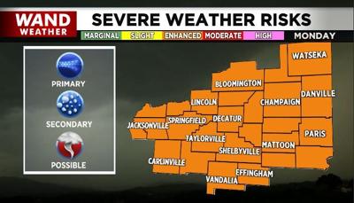

DECATUR, Ill. (WAND) - Monday brings a threat of strong storms to our area. The Storm Prediction Center includes essentially the entire state of Illinois in a level 3 out of 5 (Enhanced) risk of severe storms. This may get upgraded to a level 4 (Moderate) risk before the storms arrive Monday.

This is a bigger deal because more ingredients are accumulating in the atmosphere. Our recent rounds of severe weather this spring have been mainly driven by surface and lower-level forcing. Monday's storm potential is so well-advertised and already at a level 3 out of 5 risk because more factors are lining up across the different levels of the atmosphere to support strong storm development. That is also why all severe weather threats are possible — large hail, strong tornadoes and damaging wind. The wind will already be strong outside of thunderstorms on Monday, so damaging wind is our main concern.
Tune into WAND News this weekend and Monday morning to get the latest timing information. Timing is one of the hardest things to pin down on a system like this, so we will be updating that constantly as we get better data. At this time, it looks like there will be a morning round of storms in Illinois which will impact the later, stronger round of storms. You can also find our latest forecasts in the WAND Weather app and on wandtv.com.
Copyright 2026. WANDTV. All Rights Reserved.


