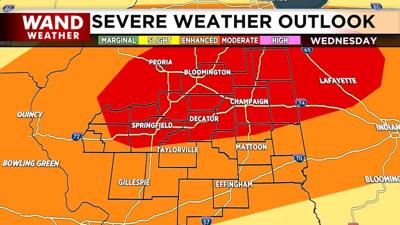
DECATUR, Ill. (WAND) - Parts of Central Illinois are under a moderate risk (4 of 5) for severe weather on Wednesday, according to the National Weather Service.
Nearly the entire State of Illinois is under some type of risk. NWS notes severe risks on five levels: Marginal, Slight, Enhanced, Moderate, and High.
The NWS said strong tornadoes, damaging winds, large hail, and flash flooding are all possible.
WATCH | The latest WAND weather forecast
The WAND Weather Team is tracking and analyzing two potential rounds of storms. The first on Wednesday morning into the early afternoon hours and then a second round from mid-afternoon until around midnight Thursday.
Wednesday's storms could be some of the strongest of 2026, according to WAND Weather. The storms are expected to move eastward across the state at a fast pace.
BOOKMARK the WAND Weather radar
A Wind Advisory is expected to be put in place around 1 p.m. on Wednesday, according to NWS. Southwest winds could be between 20 and 30 miles per hour with gusts up to 45 miles per hour.
A Flash Flood Watch will also be in place for Wednesday for areas along I-74 between Bloomington and Peoria. Rainfall rates could be 2 to 3 inches over an hour or two on Wednesday.
Wednesday's severe weather comes a week after several tornadoes caused damage in Central Illinois, including at Springfield's airport. NWS confirmed 12 tornadoes across the area, which brings the WAND viewing area total to 50.
The entire state has nearly 140 confirmed tornadoes. In 2025, Illinois saw 126 tornadoes, according to the Illinois State Climatologist.
Stay up-to-date with regular video forecasts, weather alerts, and a live radar in your neighborhood with the WAND Weather app. It's available for download in your phone's app store.
Copyright 2026. WANDTV. All Rights Reserved.


